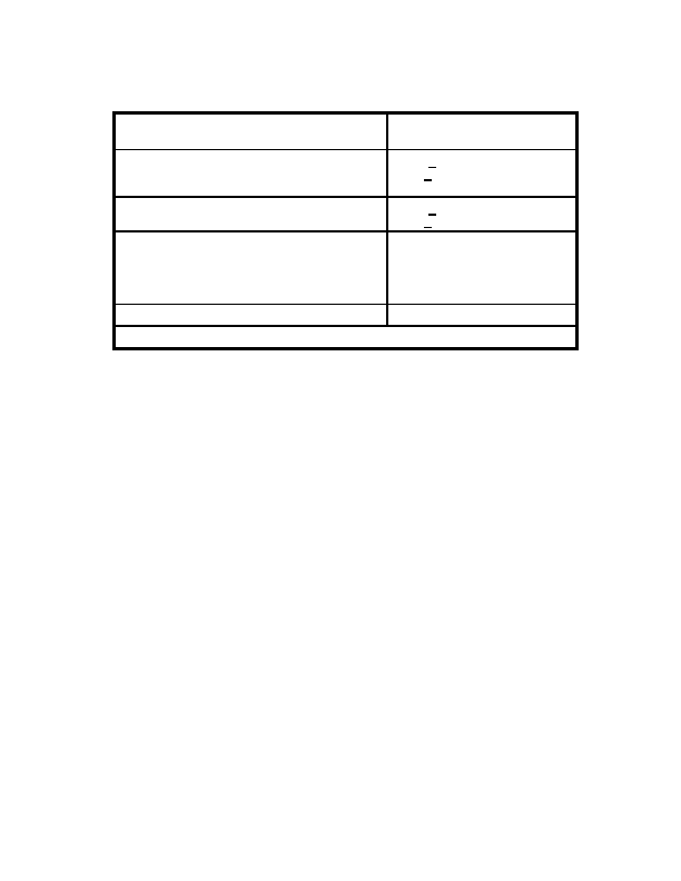
Table B 4. Methods of Determining and Accuracy of WGS 84 Coordinates
Method of Determining
Achievable
WGS 84 Coordinates
Accuracies (1s)
1. Directly Established in WGS 84 Coordinate
F and + 1 m
System via a Satellite Point Positioning
H + 1 to 2m
Solution
2. By Transformation from Doppler (NSWC 9Z 2)
F and + 2 m
Coordinates by Bias Removal
H + 2 to 3m
3. By Transformation of WGS 72 Coordinates:
Same as 2., Above Dependent on
(a) At Doppler Sites
the Originating Local Datum
(b) At non Doppler Sites where WGS 72
Coordinates and Transformation
coordinates were Obtained Indirectly from Local
Errors*
Datums
4. By Transformation of Local Datum Coordinates
Same as 3.(b) Above
*See DMA TR 8350.2 A, 1 December 2024
B.9 SUMMARY
WGS 84 is a state of the art global geodetic reference system based on the use of
data, techniques, and technology available within DMA through early 1984 and
replaces its predecessor WGS 72. The WGS 84 reference frame, EGM, geoid, and
datum transformation parameters (with local datums) are more accurate and relate
more datums (83 compared to 27 for WGS 72).
These improvements can be translated into more accurate maps and charts, geodetic
positioning, geoidal heights, improved satellite orbits, and the capability to relate more
local datums worldwide to a unified system.
B.10 REFERENCES
1.
B.I.H., "Bureau International de l Heure Annual Report for 1984, "Paris, France,
1984.
2.
Moritz, H., "Geodetic Reference System 1980," Bulletin Geodesique, 54(3):00
00,
1980.
3.
Department of Defense World Geodetic System 1984, It s Definition and
Relation ships with Local Geodetic Systems; DMA TR 8350.2 Washington, DC
30 September 1987.
B 9
<< < GO > >>