From Table B 4, it is noticed that Method 1 (where a WGS 84 site is established through
direct satellite observational data) gives the most accurate positional fix of 1 2 meters.
Method 4 (the least accurate) is entirely dependent on the local/regional distortion of the
local geodetic datum.
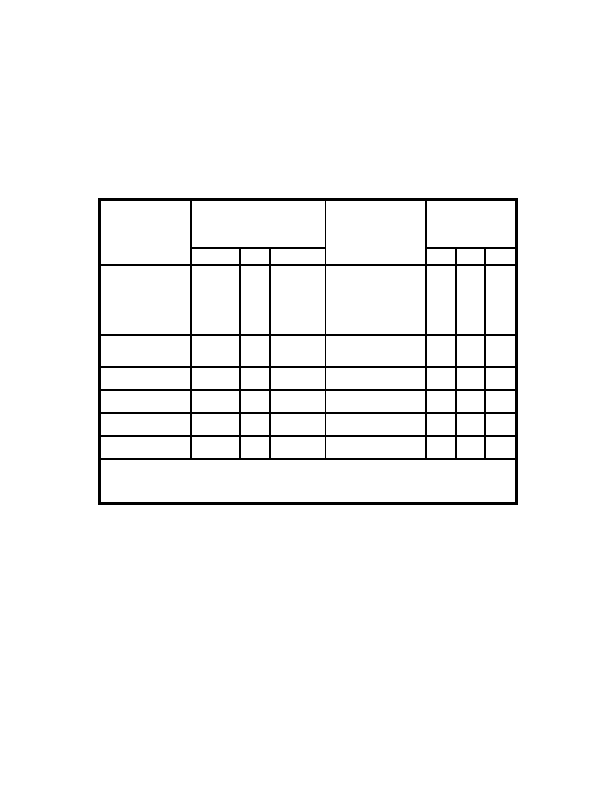
Table B 3. Transformation Parameters Local Geodetic Systems to WGS 84
(For Complete Table See Reference 4.)
Number of Doppler
Reference Ellipsoids and
Stations Used to
Local Geodetic
Parameter Differences**
Determine
Transformation
Systems*
Transformation
Parameters**
Parameters
Name
Da(m)
Df x 10
4
DX(m) DY(m) DZ(m)
PROVISIONAL SOUTH
International 251
0.14192702
63
288
175
376
AMERICAN 1956
Mean Value
(Bolivia, Chile,
Colombia, Ecuador,
Guyana, Peru, and
Venezuela)
PUERTO RICO
Clarke 1866 69.4
0.3726439
11
11
72
101
Puerto Rico and
Virgin Islands
QATAR NATIONAL
International 251
0.14192702
3
12
283
22
Qatar
QORNOQ
International 251
0.14192702
South Greenland
2
164
138
189
REUNION
International 251
0.14192702
Mascarene Island
1
94
948
1262
ROME 1940
International 251
0.14192702
Sardinia Island
1
255
65
9
*Geoid heights computer using spherical harmonic expansion and WGS 894 EGM coefficient set
(n=m=180), then referenced to the ellipsoid and orientation associated with each of the local
geodetic systems
**WGS 84 minus local geodetic system
B 8
<< < GO > >>